Maps scanned or digitally re-rendered for use on smartphones or other mobile devices.
Please ensure you check whether the ranges are active before your trip.
Dartmoor Range Firing Times
Dartmoor Hi Res Camping Map
This map details the current permitted camping areas on the moor. This is a large file and best saved to your phone and opened in Adobe or another dedicated PDF app.
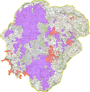
Dartmoor Camping Map PDF – Note this map is no longer current but can still be used as a guide. For the latest interactive map, visit – https://www.dartmoor.gov.uk/about-us/about-us-maps/new-camping-map
The purple areas indicated the permitted camping area, the red areas indicate the areas where no camping is permitted.
Disclaimer, some land owners may allow camping on areas outside of the purple area, it is up to the individual to research and contact the landowner.
Dartmoor MOD Trailing Areas
The following maps have been digitally re-rendered to allow calling up to 400% of their original whilst retaining a good level of detail. They are large files abe best viewed once downloaded to your device and opened in Adobe or another dedicated PDF viewer.
Dartmoor Training Area – Detailed
Dartmoor Training Area including Common Boundaries
Disclaimer, these maps remain the property of the MOD. They were accurate on the date of upload and I will try to update them with any alterations that may be published in the future.
Useful Links and Resources
Dartmoor & Exmoor Wild Camping – Facebook Group